| |
Jesuit
Road Building to Facilitate the Mission Process
continued...
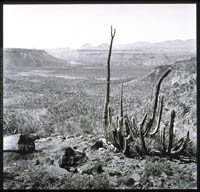
- El
Camino Real crosses the Llano del Gentil as it approaches
Misión de San Borja, 1967.
The old Jesuit road follows surveyor-straight legs as it heads north
to the mission from the foot of a tall grade called the Cuesta del
Gentil. The pass at the top of grade is crowned by stunted specimens
of two characteristic local plants, cirio [Fouquiera columnaris]
and garambullo [Lophocereus schottii]. Also visible when I passed
in 1967 was this trail marker that may well have dated from mission
times.
- El
Camino Real crosses the Llano del Gentil - trail marker,
1967
- Misión
de Santa Maria de los Angeles, 1967
In 1767, less than a year before their expulsion from the peninsula,
the Jesuits established their last California mission, intending
it to be another step toward the north and a linkage with Jesuit
missions of Sonora- this conjunction had been a dream of Padres
Kino and Salvatierra as early as 1691 when they began to plan their
mission to California. Santa María was soon by-passed in
the bustle of opening Alta California and establishing a Franciscan
mission and then Dominican missions just to the north. During its
brief years, Santa María was administered successively by
the three orders; no one knows which built the adobe structures
whose picturesque ruins mark the now-quiet, palm-filled arroyo.
|
|
Santa
Ana, California's First Mining Camp and Secular Village
An eyewitness
description of the peninsula, written in 1740, mentioned the presence
of silver at a site called Santa Ana. Manuel de Ocio, California's
first entrepreneur, knew the Santa Ana region well. As a soldier,
he picked up supplies at the landing place on the gulf shore opposite
the prominent island of Cerralvo and escorted them to his assigned
base at Todos Santos, sixty miles away. The trail he followed passed
within a few hundred yards of Santa Ana on its way to the peninsular
divide. By 1748, Ocio had laid claim to Santa Ana and begun to develop
the place with a newly hired crew. Initially, Ocio had brought in
several dozen men, some already living in California- ex-soldiers,
soldiers' sons, and ex-mission servants while others were mine workers
hired in New Spain. Within two or three years, Ocio's primitive smelting
and amalgamation treatments of ore where producing several hundred
pounds of silver a year, a tiny amount when compared to production
elsewhere in New Spain, but tantalizing to promise to royal officials
who never before had received a peso in taxes on any California mineral
production.
- Bahía
de la Ventana and the Surgidero de Cerralvo, 1992
The anchoring place far down this beach served pearlers as early
at the mid-17th century, then Manuel de Ocio as he developed Santa
Ana, and finally Visitor General José de Gálvez and
all his retinue when they visited California in 1768 to set in motion
the occupation of Alta California.
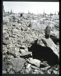
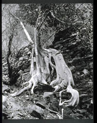
- Ruins
of an eighteenth century silver refining installation, 1974
The remains of a smelting oven and an aqueduct can yet be seen at
a site called El Mortero, a few hundred yards from the Real de Santa
Ana. A young specimen of zalate, the peninsular wild fig, spreads
its buttressing roots over and into the aqueduct.
- Real
de Santa Ana, 1974
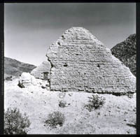
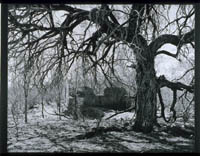
- Adobe
ruins at Santa Ana, 1974
When Manuel de Ocio opened his mining camp in 1748, his workers
and their families soon created a Hispanic village. In 1768, after
the Jesuits were expelled from California, the King's representative,
José de Gálvez, came from Mexico to direct the opening
of Alta California. For several months, Gálvez occupied Ocio's
headquarters at Santa Ana and it was their that he, Governor Gaspar
de Portolá, and Padre Junípero Serra planned the expeditions
by land and sea that were to occupy the new territory to the north.
Santa Ana's mines soon played out and the place was virtually deserted
by the time of Mexican Independence (1821).
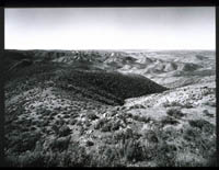
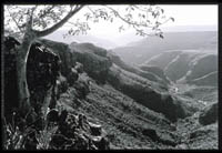
- San
Telmo Valley seen from foothills of the Sierra de San Pedro Mártir,
1968.
Governor Gaspar de Portolá chose the experienced California
captain, Fernando de Rivera y Moncada, to lead the first ground
party to Alta California. Rivera y Moncada had led earlier explorations
to a point about half way to San Diego from the Jesuit's most northerly
mission. Therefore, in 1769, he started north on a familiar route
into the Sierra de San Pedro Mártir. Rivera's party then
went on into unexplored parts of the sierra and, judging from their
diaries, probably emerged from the mountains to encounter this scene.
The date was April 13, 1769; a month later the land expedition was
united at San Diego with members of the expedition who had gone
by sea.
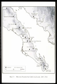
- Map of Missions.
Ranch Types
and Ranch Locations
- View
of the west looking down the arroyo of Rancho del Potrero, 1980
Two ranch clearings appear almost as specks in this great cleft
in the sierra.
|