| |
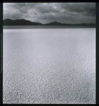
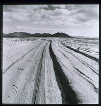
Laguna
Seca de Chapala [1967]
After 250 miles
of rocky or sandy rises, falls, and interminable twists, most travelers
were astonished to find themselves looking down on the spectacle of
a level plain apparently devoid of life or blemish. This almost-always
dry lake bed was in fact only a couple of miles in length or breadth,
but in its serenity seemed vast. Once a driver got his vehicle down
to the edge, he was greeted by dozens of divergent wheeltracks that
fanned out to either side. When a heavy rain does fall, a shallow
lake fills the basin from rim to rim. Soon it filters down and evaporates
to leave an incredible sea of mud. Each driver forced to cross in
time of mud swung wide to avoid sinking in the ruts of his predecessors,
hence the multiplicity of tracks. But all traffic converged on Rancho
de Laguna Chapala out on a tiny man-made rise in the lake bed. Here
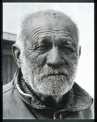
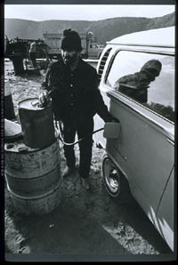
lived Arturo Grosso, one of the premier characters in the drama that
accompanied driving the peninsula. Don Arturo offered meals, occasionally
gas, and always conversation.
- San
Felipe as it was..., 1952
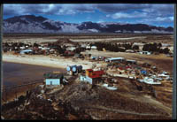
Once upon a time, San Felipe was the sleepy fishing village at the
end of the long dirt road. It had no hotel and the most modest of
restaurants, actually the rival kitchens of two enterprising boatbuilder's
wives. The long beaches were populated only by birds and a few dories
pulled up to the high tide line. Needless to say, progress has transformed
San Felipe.
- El
Pedregoso, 1990.
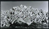
This striking hill some 13 miles north of Laguna Seca Chapala lay
immediately east of the old road and was visited and photographed
by nearly every tourist in transit. Today's paved highway passes
two hundred yards to the east and affords a less impressive view.
Most people now drive by with little more than a glance. The giant
boulders [note human figure in center] appear to have been stacked
by some mysterious force, but El Pedregoso is actually the in situ
remains of a granite monolith long exposed to erosive forces.
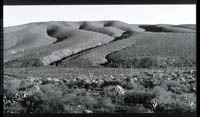
- Landform
fifteen mile southeast of El Rosario, 1990
- Rancho
de Arenoso, 1971
Today in ruins, this home was long occupied by friendly people,
including good cooks. But the vision that leaps out of memory is
that of an unexpected propane refrigerator and its stock of cold
beer. Requiescat in pace Servel.
- Laguna
Seca de Chapala, 1967
- Laguna
Seca de Chapala, 1967
- Arturo
Grosso, 1967
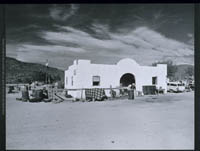
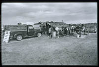
- "Gas
Station/Rest Stop" near Mezquital, 1971
At irregular intervals, from 20 to 50 miles apart, local residents
put up roadside structures that allowed them to offer meals and
gasoline to passing truckers and tourists. Their buildings employed
local materials as well as plywood, galvanized sheet iron, and miscellaneous
salvage from nearby beaches. They were low, open, and ugly and provided
poor protection when cold, damp winds blew off the Pacific. But
the weather was usually fine, the people cheerful, the coffee and
sea food good. Few drivers resisted the temptation to take a break
from the trail, gas up, and relax while exchanging stories with
attendants or fellow travelers. Caravanserai peninsularis did not
have the style or color of its Mid-East prototypes, but each now-vanished
example lingers in the memory of those who plied the difficult but
beguiling wheeltrack that could be followed as far as Cabo de San
Lucas.
- "Gas
Station/Rest Stop" near Mezquital, 1971
- Roadside
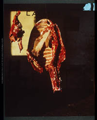
butcher shop in Villa Insurgentes, 1967.
|