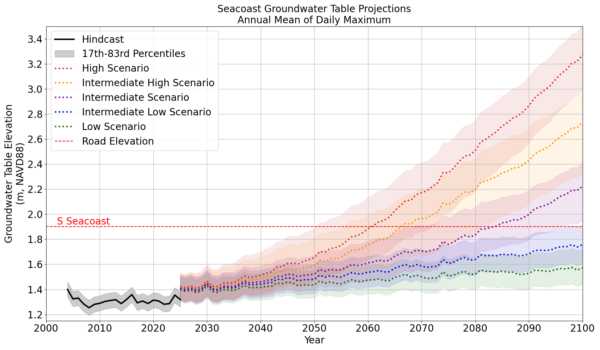
Data from: Flooding Projections due to Groundwater Emergence Caused by Sea Level Variability
Data from: Flooding Projections due to Groundwater Emergence Caused by Sea Level Variability
About this collection
- Extent
-
1 digital object.
- Cite This Work
-
Barnes, Austin T.; Merrifield, Mark A.; Bagheri, Kian; Levy, Morgan C.; Davani, Hassan (2025). Data from: Flooding Projections due to Groundwater Emergence Caused by Sea Level Variability. UC San Diego Library Digital Collections. https://doi.org/10.6075/J0N29XB3
- Description
-
In December 2021, we installed four groundwater monitoring wells in Imperial Beach, California, to study the effects of sea level variability and implications for flood risks. We collected time series of groundwater table elevation (GWT) relative to a fixed vertical datum and local land surface elevation from 8 December 2021 through 14 May 2024. In each groundwater monitoring well, a single unvented pressure sensor (RBR Solo) was attached to Kevlar line and submerged ~1 m below the GWT. From 8 December 2021 through 21 November 2023, total pressure was recorded at 1 Hz; from 22 November 2023 through 14 May 2024, sampling occurred at 0.1 Hz. Gaps in sampling are a result of battery failures leading to data loss. To estimate hydrostatic pressure from total pressure measurements we subtracted atmospheric pressure measurements that were collected every 6 min from NOAA's National Data Buoy Center (NDBC) station SDBC1-9410170 at the San Diego airport and linearly interpolated to match sensor samples. Hydrostatic pressure is converted to sensor depth below the water table. We determined an average well water density, ρ, using intermittent vertical profiles of conductivity-temperature-depth (CTD) and the TEOS-10 conversion (Roquet et al. 2015).
This object includes MATLAB (.mat) and HDF5 (.h5) files that contain the raw total pressure measurements from unvented RBR solos. The original Ruskin files (.rsk) are not included and have been converted to MATLAB files without loss of fidelity. Intermittent CTD profiles used to estimate well water density structure are included as CSV files. GWT that have been processed using atmospheric pressure and vertical datum measurements are included as HDF5 files. The object has five main directories, one for each of the four groundwater wells and one for data downloaded from other sources for archival and reproducibility purposes. - Date Collected
- 2021-12-08 to 2024-05-14
- Date Issued
- 2025
- Authors
- Co Principal Investigators
- Funding
-
Support for this study was provided by the U.S. National Science Foundation (2113984, 2113987, 2239602, and 2205239), by the U.S. Army Corps of Engineers (W912HZ1920020), and by the California Department of Parks and Recreation, Natural Resources Division Oceanography Program (C19E0026).
- Geographic
- Topics
Formats
View formats within this collection
- Language
- English
- Identifier
-
Identifier: Austin T. Barnes: https://orcid.org/0000-0002-9206-0187
Identifier: Hassan Davani: https://orcid.org/0000-0001-5428-4844
Identifier: Kian Bagheri: https://orcid.org/0000-0002-7639-6297
Identifier: Mark A. Merrifield: https://orcid.org/0000-0002-5026-8393
Identifier: Morgan C. Levy: https://orcid.org/0000-0002-1202-4195
- Related Resources
- Barnes, A. T., Merrifield, M. A., Bagheri, K., Levy, M. C., & Davani, H. (submitted). Flooding Projections due to Groundwater Emergence Caused by Sea Level Variability. Earth’s Future.
- California Department of Water Resources, California Irrigation Management Information System (CIMIS) Overview: https://cimis.water.ca.gov/SpatialData.aspx
- Centralized Data Management Office (CDMO), National Estuarine Research Reserve System: https://cdmo.baruch.sc.edu/
- National Aeronautics and Space Administration (NASA), Sea Level Change: Observations from Space (sealevel.nasa.gov)
- National Oceanic and Atmospheric Administration (NOAA), National Data Buoy Center -- Station SDBC1 - 9410170 - San Diego, CA: https://www.ndbc.noaa.gov/station_history.php?station=sdbc1
- National Oceanic and Atmospheric Administration (NOAA), Tides and Currents -- Observed Water Levels at 9410230, La Jolla CA: https://tidesandcurrents.noaa.gov/waterlevels.html?id=9410230
- Austin Barnes. (2025). aubarnes/ImperialBeachGroundwater: Source code for: 'Flooding Projections due to Groundwater Emergence Caused by Sea Level Variability (v1.0.1). Zenodo. https://doi.org/10.5281/zenodo.14969632
- Image credit: Austin Barnes. "Seacoast Groundwater Table Projections."
Primary associated publication
Source data
Software
Collection image
 Library Digital Collections
