Browse by Collection
View current collections below. Click an image or link for a full description.
Page 5 of 24
Search Results
-
 Collection
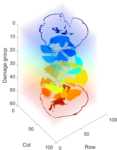
Data and Code from: 3D Reconstruction and Segmentation of Barely Visible Impact Damage in Composites from Pulse-Echo Ultrasonic C-Scans
- 26 processed pulse-echo ultrasonic C-scans of composites with barely visible impact damage with varying layups and impact energies, with calculated time-of-flight, contours of damaged regions, damage depth map, and 3D reconstruction of the damage state.
- Date: 2022 to 2023
-
 Collection
Data and Code from: Buoyancy Forcing Dominates the Cross-Equatorial Ocean Heat Transport Response to Northern Hemisphere Extratropical Cooling
- Fortran source code to developed to override wind stress in the Community Earth System Model (CESM) v. 1.2 and resulting GCM output data from Luongo et al. (2022).
- Date: 2021-05 to 2021-10
-
 Collection
Data and Code from: Measuring Turbulent Dissipation with Acoustic Doppler Velocimeters in the Presence of Large, Intermittent, Infragravity Frequency Bores
- Velocity data from Los Peñasquitos Lagoon and processing code to help researchers reproduce ADV de-spiking and turbulent spectrum calculation methods that work in the presence of non-linear, intermittent dynamics as well as a generally applicable, robust inertial sub-range fitting method.
- Date: 2020-02-02 to 2020-02-14
-
 Collection
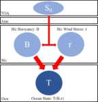
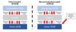
Data and Code from: Retaining Short-Term Variability Reduces Mean State Biases in Wind Stress Overriding Simulations
- Fortran source code developed to override wind stress with a climatology in the Community Earth System Model (CESM) v. 1.2 and resulting GCM output data from Luongo et al. (2024).
- Date: 2022 to 2023
-
 Collection
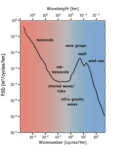
Data from: A Broadband View of the Sea Surface Height Wavenumber Spectrum
- This collection has SSH observations from airborne lidar used in the analysis presented in Villas Bôas et al. (2022)
- Date: 2019-03-28 to 2019-04-10
-
 Collection
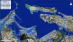
Data from: A climate vulnerability assessment of cultural heritage in the La Fortaleza and San Juan National Historic Site World Heritage Site
- Inundation threats related to climate change in San Juan Bay, Puerto Rico, which includes the World Heritage Site of La Fortaleza and San Juan National Historic Site. The map contains separate layers for sea level rise from NOAA's Sea Level Rise Viewer Tool, and layers for other relevant variables produced by the Coastal Resilience Evaluation and Siting Tool (CREST), acquired in Spring 2023.
- Date: 2023-04-03 to 2023-06-09
-
 Collection
Data from: A Climatic Sand Management Model for Cardiff State Beach, CA
- Annual mean beach width and nearshore sand volume survey estimates for 2000-2019 at South Torrey Pines and Cardiff State Beach, CA, and associated sediment budget modeling code for Cardiff State Beach.
- Date: 2000 to 2021
-
 Collection
Data from: A Glimpse through Time and Space: Visualizing Spatial Continuity and History-making at Çatalhöyük, Turkey
- This collection includes 3-D models, derived 3-D renders, Unity 3D asset packages, a Win64 3-D app, and related metadata that reconstruct both spatially and temporally (4-D) the ‘Shrine’ 10 sequence at the Neolithic site of Çatalhöyük, Turkey
- Date: 2017 to 2019
-
 Collection
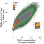
Data from: A Living Vector Field Reveals Constraints on Galactose Network Induction in Yeast
- To study how cellular traits produce population phenotypes, we built living vector fields from single-cell timecourses of the proteins Gal3p and Gal1p as yeast switched to galactose from other nutrients. This collection has data and analysis codes.
- Date: 2015 to 2016
-
 Collection
Data from: A new method for diagnosing effective radiative forcing from aerosol-cloud interactions in climate models
- This dataset includes a new method for estimating shortwave ERFaci from liquid clouds using cloud radiative kernels and MODIS joint histograms, offering insights into the Twomey effect, liquid water path, and cloud fraction adjustments.
- Date: 2024
-
 Collection
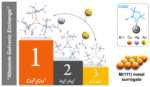
Data from: Absolute Templating of M(111) Cluster Surrogates by Galvanic Exchange
- Density Functional Theory Methods were used to calculate several carbene coinage metal clusters and their intermediates in a galvanic exchange process. Also, these methods calculated NICS scan, and WFN method for ELF.
- Date: 2019 to 2020
-
 Collection
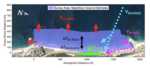
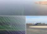
Data from: Airborne observations of shoaling and breaking internal waves
- This collection contains data presented in: "Airborne observations of shoaling and breaking internal waves." This includes a mosaic of sea surface temperature, spectral analysis of temperature structures, surface velocities, and areas undergoing breaking.
- Date: 2015-08-01
-
 Collection
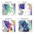
Data from: Airborne observations of surface winds, waves and currents from meso to submesoscales
- Coincident and collocated high-resolution observations of surface currents and directional properties of surface waves collected from an airborne instrument, the Modular Aerial Sensing System (MASS), collected off the coast of Southern California.
- Date: 2021-05-18 through 2021-11-05
-
 Collection
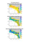
Data from: Airborne remote sensing of concurrent submesoscale dynamics and phytoplankton
- This archive contains the code and data needed to generate the figures in the publication: "Airborne remote sensing of concurrent submesoscale dynamics and phytoplankton" (Lang, Sarah E.; Omand, Melissa M.; Lenain, Luc). Data presented was collected as part of the Submesoscale Ocean Dynamics Experiment (S-MODE).
- Date: 2021-10-29 to 2021-10-30
-
 Collection
Data from: Allostery through the Computational Microscope: cAMP Activation of a Canonical Signalling Domain
- This collection contains the molecular dynamics trajectories scripts and models used in the paper “Allostery through the computational microscope: cAMP activation of a canonical signalling domain”.
- Date: 2014-08-24
-
 Collection
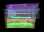
Data from: Arctic ice-ocean interactions in an 8-to-2 kilometer resolution global model
- This data collection represents all UH8to2 model data used for the publication "Arctic ice-ocean interactions in an 8-to-2 kilometer resolution global model". This includes ocean and sea ice characteristics from the 2017-2020 UH8to2 model run.
- Date: Model representation: 2017 to 2020
-
 Collection
Data from: Are AI weather models learning atmospheric physics? A sensitivity analysis of cyclone Xynthia
- This collection contains the data for the manuscript titled "Are AI Weather Models Learning Atmospheric Physics? A Sensitivity Analysis of Cyclone Xynthia", which is necessary to reproduce the results presented.
- Date: 2024
-
 Collection
Data from: Autumn precipitation: the competition with Santa Ana winds in determining fire outcomes in southern California
- This dataset includes two versions of the Santa Ana Wind Regional Index (SAWRI) and Livneh precipitation data from 1948-2018.
- Date: Compiled: 1948 to 2018
-
 Collection
Data from: Building Cultural Heritage Resilience through Remote Sensing: An Integrated Approach using Multi-temporal Site Monitoring, Datafication, and Web-GL Visualization
- This collection integrates highly accurate 3D snapshots of Bodie's historic buildings before/after disturbance, or post-restoration, and other 3D geospatial data that were used to monitor and digitally preserve important cultural resources at Bodie California State Historic Park.
- Date: 2015 and 2020
-
 Collection
Data from: Calibrated absolute seafloor pressure measurements for geodesy in Cascadia
- Raw and corrected pressure data from campaign-style surveys of absolute calibrated sea pressure using an Absolute Self-Calibrating Pressure Recorder (ASCPR) in the Cascadia subduction zone from 2014 to 2017.
- Date: 2014 to 2017